Petroleum systems modelling
Description
Petroleum systems analysis is a unifying concept that encompasses all of the geologic elements (source rock, migration pathway, reservoir, seal and overburden rock) and processes (trap formation, hydrocarbon generation, migration and accumulation, preservation, alteration and leakage) and all genetically related petroleum that originated from one pod of active source rock and occurs in shows, seeps, or accumulations (modified after Magoon and Dow, 1994).
History
Basin Modelling was introduced in the late 1970s as the term describing the quantitative modelling of geological processes in sedimentary basins on geological timescales (Hantschel and Kauerauf, 2009). Depth, age, and lithologic description of a stratigraphic sequence, cross section, or an entire basin in conjunction with information about the thermal history of the basin setting are utilised to simulate its geologic history and predict petroleum generation, expulsion, migration, and accumulation. Over time, as more specialised tools and sophisticated workflows have been developed, the term Petroleum Systems Modelling was established.
Petroleum systems models may be 1D, 2D or 3D, referring to the spatial dimensions: the time dimension is implied in all cases. In all cases, models should be "fit for purpose". The complexity of the models and the amount of data required (or assumptions made) increases with the number of dimensions almost exponentially.
In unexplored areas, one-dimensional (1D) modelling possibly based upon limited information available may be appropriate, whereas the complexities involved in 3D modelling may not be justified. The main questions addressed by 1D models are if and when source rock maturation and hence hydrocarbon generation and expulsion may have occurred.
Two-dimensional (2D) models use a cross section to build the simulation. In addition to predictions about if and when generation and expulsion may have occurred, potential vertical migration pathways may be predicted.
Three-dimensional (3D) basin models are generally built at reservoir to basin scales. With a 3D model, potential migration pathways in three dimensions can be visualised and volumes of hydrocarbons that may have migrated and been trapped can be estimated.
All models are wrong (Box, 1976).
... but some are useful (Box, 1978).
Petroleum systems modelling should be treated as a tool with which to test scenarios and inform risk and uncertainty, not as a tool to generate a unique model based on the current best guess of the subsurface.
One-dimensional (1D) Modelling
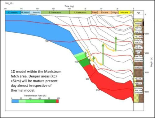
1D basin modelling utilises depth, age and lithologic descriptions of a stratigraphic sequence in conjunction with information about the thermal history of the basin setting to simulate its geologic history in order to predict petroleum generation and expulsion (Dembicki Jr., 2017). 1D basin models of existing wells can be utilised to calibrate 3D basin models.
1D models may be of a well section, based upon information for a drilled well, or of a synthetic well section, based upon either seismic data or published information. 1D models provide simulation of temperature and maturation level against depth but not hydrocarbon migration. Minimum input data for 1D models include:
- Layer boundaries (depths) and eroded thickness for any eroded layers
- Deposition ages for layers and erosion ages for any eroded layers
- Lithology, facies, source rock properties etc. for all layers including eroded layers
Two-dimensional (2D) Modelling
2D models are typically based upon a seismic section but may be based upon geological cross-sections, interpolating the stratigraphy between two wells. As well as simulating temperature and maturation level against depth, 2D models also incorporate hydrocarbon migration along the line of section. The minimum input data for 2D models include depth horizons below seabed (or elevation if onshore), in addition to those required for 1D modelling.
Three-dimensional (3D) Modelling
3D models are typically based upon interpreted, depth-converted seismic surfaces. They provide simulation of temperature and maturation level against depth as well as hydrocarbon migration in 3D. Minimum input data are similar to those for 2D models. In 3D models, faults may act as seals or as open migration conduits, either continually or for specific time intervals. Other migration complexities include salt tectonics.
A detailed list of input and calibration data is given in Model input data.
References
Box, G.E.P., 1976. Science and Statistics. Journal of the American Statistical Association 71, 791–799.
Box, G.E.P., 1978. Robustness in the Strategy of Scientific Model Building, Technical Summary Report #1954. University of Wisconsin - Madison Mathematics Research Center.
Dembicki Jr., H., 2017. Practical Petroleum Geochemistry for Exploration and Production. Elsevier, p. 342.
Hantschel, T., Kauerauf, A.I., 2009. Fundamentals of Basin and Petroleum Systems Modeling. Springer Berlin Heidelberg. doi:10.1007/978-3-540-72318-9
Magoon, L.B., Dow, W.G., 1994. The Petroleum System - From Source to Trap. AAPG Memoir 60.